168
168
Oct 28, 2012
10/12
by
FOXNEWS
tv
eye 168
favorite 0
quote 0
this will be the event they feared irene will be. it will be worse than the event they thought irene might be. it's an incredible storm. it is a hurricane right now, it is gaining energy from the warm water source it has here. but it is going to be tobegin a process of gaining energy from a cold air mass here across parts toward the eastern u.s., that combination will cause the storm to explode in its intensity. it is very strong. it is going to cause it to expand in its wind field. so we are talking about multi-facets to the storm. one is the rain. we are seeing the rain here across parts of the outer bank, with 5, 6 inches falling. but many areas will see 5 to 10 inches of rain. so there will be a lot of inland flooding. and the storm surge is the most deadly thing that comes from any kind of tropical storm. when have you a hurricane that comes into jersey, that puts the biggest and worst of the storm surge here to that upside-down l-shape. the water has nowhere to go and it causes potentially catastrophic flooding in new york city
this will be the event they feared irene will be. it will be worse than the event they thought irene might be. it's an incredible storm. it is a hurricane right now, it is gaining energy from the warm water source it has here. but it is going to be tobegin a process of gaining energy from a cold air mass here across parts toward the eastern u.s., that combination will cause the storm to explode in its intensity. it is very strong. it is going to cause it to expand in its wind field. so we are...
1,235
1.2K
Oct 29, 2012
10/12
by
CNNW
tv
eye 1,235
favorite 0
quote 0
we got through irene. this will be tougher, but we can get through this also. >> are you finding people are heeding the warnings already, sir? >> yes. we have about 150-plus folks in our shelters. we're getting tweet information @michaelnutter. our 311 system is getting a lot of calls. people asking for information. i think people know we're taking this seriously. president obama signed an emergency declaration. we're working through our state and governor corbett. we're constantly pumping out information to folks. people know that this is the real deal. they knew that irene was tough. this is going to be tougher and probably last longer because this is a slow moving storm. so it's just going to expand on the amount of rain and wind and that's a tough combination for us in a big old northeastern city. >> it sure is. mayor michael nutter joins us from philadelphia. thank you, sir, for your time. we certainly appreciate it. let's head to baltimore, shall we? let's chat with stephanie rowelings blake. she's t
we got through irene. this will be tougher, but we can get through this also. >> are you finding people are heeding the warnings already, sir? >> yes. we have about 150-plus folks in our shelters. we're getting tweet information @michaelnutter. our 311 system is getting a lot of calls. people asking for information. i think people know we're taking this seriously. president obama signed an emergency declaration. we're working through our state and governor corbett. we're constantly...
298
298
Oct 29, 2012
10/12
by
CNNW
tv
eye 298
favorite 0
quote 0
but that was at the height of irene. irene came on shore well to our north. this storm will bring this water up as much as another eight feet, which means the boardwalk will be compromised and the water will be going over the top of that. that's why this area's been evacuated. shelters are open. there's been 600 people that have taken advantage of that. just spoke with an official from the fire department here. a few minor calls into the asbury park fire department with some trees and some power lines down but no widespread damage as of yet. and no rescue operations under way. they certainly hope that trend will continue through the overnight period. in the next 12 hours, that's when things are going to get really hairy. carol? >> rob marciano reporting live from asbury park. thank you, rob, appreciate it. if you want a sense of just how seriously local officials are taking this approaching storm, consider this -- the new jersey weather service issued this dire warning yesterday for anyone ignoring the evacuation orders. quote, if you are reluctant, think abo
but that was at the height of irene. irene came on shore well to our north. this storm will bring this water up as much as another eight feet, which means the boardwalk will be compromised and the water will be going over the top of that. that's why this area's been evacuated. shelters are open. there's been 600 people that have taken advantage of that. just spoke with an official from the fire department here. a few minor calls into the asbury park fire department with some trees and some...
182
182
Oct 29, 2012
10/12
by
MSNBCW
tv
eye 182
favorite 0
quote 0
during irene it was 4.4. we expect to double what we had in irene. that's the problem. that's what kicked in yesterday and that's why the mandatory evacuation order was kicked in. the storm is deep in low pressure, and we expect the wind field to push this water up through long island sound and just to give you an example. you can see what's going on here in terms of how high water is. it's below the sea wall, but it's probably going to be about a good third of the way up this pole. that brings it all the way back into the battery and probably into lower parts of manhattan as well. parts of wall street will probably flood, so we anticipate this water to be much higher. the only difference in it could be the fact that it's going to come up gradually as opposed to quick like with the storm surge. not gradual in like 20 minutes but maybe over an hour or so we see that water coming up and coming up. we see the tunnels here shut down. the brooklyn tunnels now shout done, the holland tunnel is closing at 2:00 this afternoon. that's an order from the governor. when you see thi
during irene it was 4.4. we expect to double what we had in irene. that's the problem. that's what kicked in yesterday and that's why the mandatory evacuation order was kicked in. the storm is deep in low pressure, and we expect the wind field to push this water up through long island sound and just to give you an example. you can see what's going on here in terms of how high water is. it's below the sea wall, but it's probably going to be about a good third of the way up this pole. that brings...
257
257
Oct 29, 2012
10/12
by
CNNW
tv
eye 257
favorite 0
quote 0
advisory on hurrican irene. we want to go to rob marciano who will tell us what this latest advisory is about. >> it's frightening, up to 85-mile-an-hour wind now. there's a possibility from reading some nuggets from the national hurricane center that it could strengthen some more. we knew we had that possibility. still over the gulf stream where waters are still warm enough to sustain a hurricane. also getting into an environment where it favored strengthening. that's what we've seen. here it is in the satellite picture. 85-mile-an-hour winds. that's a moderate strength category one storm with possible strengthening as we go through time. about 380 miles south of new york city it's movement has picked up northerly about 15 miles an hour and we still expect that turn toward the west later on. this is huge. reading some technical stuff, the tropical storm force winds, diameter nearly 800 miles wide. that is huge. the second largest tropical system we've seen in the last few decades. hurricane force winds extend 1
advisory on hurrican irene. we want to go to rob marciano who will tell us what this latest advisory is about. >> it's frightening, up to 85-mile-an-hour wind now. there's a possibility from reading some nuggets from the national hurricane center that it could strengthen some more. we knew we had that possibility. still over the gulf stream where waters are still warm enough to sustain a hurricane. also getting into an environment where it favored strengthening. that's what we've seen....
106
106
Oct 29, 2012
10/12
by
CNNW
tv
eye 106
favorite 0
quote 0
looks like it will be higher than irene. that has folks worried in new york harbor and here in new jersey. here's what governor chris christie had to say about his warning to the state yesterday. >>. >> so, don't be stupid, get out and go to higher ground. the margin for me being wrong and you staying at a friend's house is significantly better than winding up with severe energy or death for yourself or for your family. >> some public officials caught heat after hurricane irene. some felt it was overblown. i stand by warnings because it's better to be safe than sorry. this is bigger and in many instances badder than hurricane irene was over 12 months ago. back to you. >> thank you. chris christie is completely right. just go to higher ground just for a couple of days. bring some stuff. if you're wrong, fine. this is not shaping up to be something anything like irene. new york city we're bracing for the impact. mass transit was shut down last night. buses, rail system were brought to a halt. 7 p.m. is when they stopped last n
looks like it will be higher than irene. that has folks worried in new york harbor and here in new jersey. here's what governor chris christie had to say about his warning to the state yesterday. >>. >> so, don't be stupid, get out and go to higher ground. the margin for me being wrong and you staying at a friend's house is significantly better than winding up with severe energy or death for yourself or for your family. >> some public officials caught heat after hurricane...
56
56
Oct 30, 2012
10/12
by
CNBC
tv
eye 56
favorite 0
quote 0
places that didn't experience flooding during irene. certainly did this time. historic event, and it will take some time to recover. >> back to you, scott. >> reynolds wolf for us from the weather channel. hurricane sandy loss estimates are as high as $10 billion, but what does this mean for the insurance stocks. let's welcome josh sterling an insurance analyst at bernstein. thanks for coming on today. >> thank you, scott. >> had an analyst on yesterday looking ahead to the storm who suggested that chub was the best physician. how would you assess who has got the best place right now in the insurance business, given the damage estimates?5zl >> well, you know, that's a great question. the truth of the matter is all will be weak for a few days. looking back in history, what happens is investors in times of uncertainty, until the companies start to report losses, generally the stocks will be weak, and, of course, you know, given this storm and given how many people who are investors and how we've been sitting at home watching television for the past couple of days
places that didn't experience flooding during irene. certainly did this time. historic event, and it will take some time to recover. >> back to you, scott. >> reynolds wolf for us from the weather channel. hurricane sandy loss estimates are as high as $10 billion, but what does this mean for the insurance stocks. let's welcome josh sterling an insurance analyst at bernstein. thanks for coming on today. >> thank you, scott. >> had an analyst on yesterday looking ahead to...
178
178
Oct 30, 2012
10/12
by
MSNBCW
tv
eye 178
favorite 0
quote 0
in irene we moved patients from zone a to zone b and zone b to c. so for better or worse, we have these experiences of patients being absorbed by other hospitals. >> mayor bloomberg instructed taxis and cars to get off the roads that they needed to keep the roads clear and that's a good reminder for people who may be in manhattan right now. in general, you talked about the assessment that will be made tomorrow morning. do you think tomorrow morning as well that the city will have a good idea of when it might be up and running, when taxis may be back on some of the roads? >> i think we'll have a much better sense tomorrow morning and, remember, twoef assess the situation in midtown manhattan but also communities all over the other boroughs, i'm hearing about extreme flooding in staten island. there's going to be a broad base assessment and what we will need to do for our business district but also the residential communities. the mayor said about car, we have flooding, for example, the hudson river, and that's in my lifetime and i've been in this cit
in irene we moved patients from zone a to zone b and zone b to c. so for better or worse, we have these experiences of patients being absorbed by other hospitals. >> mayor bloomberg instructed taxis and cars to get off the roads that they needed to keep the roads clear and that's a good reminder for people who may be in manhattan right now. in general, you talked about the assessment that will be made tomorrow morning. do you think tomorrow morning as well that the city will have a good...
264
264
Oct 28, 2012
10/12
by
CNNW
tv
eye 264
favorite 0
quote 0
. >> and you mentioned irene, and while that was a year ago, new york city did not get pummeled by irene. the mayor of new york city is urging very seriously to take this warning of this storm. there's nothing going to be no hot water, there's going to be no heat in those low-lying areas, he certainly is encurlinging people to go to those evacuation locations or seek higher ground, or find a friend who is in a higher level place. >> i felt for the mayor when i was in lincoln, nebraska do my first weather show. call for the radar, is the radar there? and it never showed up. the mayor talked about -- but we made one here for you to all of the low areas that would be if we do get this eight to ten b and then all of a sudden we have a whole other list of things to do. in all of those public places, they are going to turn off the heat and the water and ac. they won't need ac, this is going to be a cold storm, they want people out of there, they truly do. >> just as we were talking, we have some new information involving the new york stock exchange. of course that's lower manhattan, according
. >> and you mentioned irene, and while that was a year ago, new york city did not get pummeled by irene. the mayor of new york city is urging very seriously to take this warning of this storm. there's nothing going to be no hot water, there's going to be no heat in those low-lying areas, he certainly is encurlinging people to go to those evacuation locations or seek higher ground, or find a friend who is in a higher level place. >> i felt for the mayor when i was in lincoln,...
157
157
Oct 30, 2012
10/12
by
FOXNEWS
tv
eye 157
favorite 0
quote 0
hurricane irene was 1.2 million, impacted house hodes. this is 2.4 million impacted households. 1.2million of the 2.4 million from pfeag, 935,000 from jcp and l. 195,000 from atlantic city electric, and 45,000 from orange and rockland. during hurricane irene restoration took eight days for full restoration. for hurricane sandy the full restoration may in fact take longer. full damage assessment will not be complete until 24 to 48 hours due to some of the weather delays. they cannot develop the timeframe for restoration until damage assessments are underway and obviously these difficult weather conditions are making this more of a challenge. however, the utility companies have continued to reach out to other states for assistance, and we are expecting additional linemen, servicemen and tree-clearing workers from states as far away as texas and indiana and even folks coming from to us from canada. it will remain extremely dangerous in areas where trees and wires are down, i ask people to use extreme caution, assume that any wire you see dow
hurricane irene was 1.2 million, impacted house hodes. this is 2.4 million impacted households. 1.2million of the 2.4 million from pfeag, 935,000 from jcp and l. 195,000 from atlantic city electric, and 45,000 from orange and rockland. during hurricane irene restoration took eight days for full restoration. for hurricane sandy the full restoration may in fact take longer. full damage assessment will not be complete until 24 to 48 hours due to some of the weather delays. they cannot develop the...
318
318
Oct 29, 2012
10/12
by
CNBC
tv
eye 318
favorite 0
quote 0
>> certainly looks to be a more powerful storm than irene was last year. as we recall, it was a little over $5 billion for our industry for that particular storm. certainly that was just the property and casualty side, not the flooding, so we expect that this will be at least of that magnitude, although we don't know for sure until there's been some real estimates, and it takes usually a couple of weeks for us to get any real hard numbers that we can track. >> don griffin, thanks for your thoughts tonight, appreciate it. >> thank you. a lot of the focus today has been on new york city because it is the financial center of the country, but clearly points further south and soon to the north are in trouble as well. hampton pearson is live in washington where federal workers will get another day off tomorrow. hampton? >> reporter: hi, michelle. more about that in a moment. we did get word late this afternoon that treasury secretary the guy anyner had a meeting with the financial security oversight council about financial markets, hurricane sandy approaching an
>> certainly looks to be a more powerful storm than irene was last year. as we recall, it was a little over $5 billion for our industry for that particular storm. certainly that was just the property and casualty side, not the flooding, so we expect that this will be at least of that magnitude, although we don't know for sure until there's been some real estimates, and it takes usually a couple of weeks for us to get any real hard numbers that we can track. >> don griffin, thanks...
125
125
Oct 29, 2012
10/12
by
FOXNEWSW
tv
eye 125
favorite 0
quote 0
water will rise and we already have water rising in excess of 6' topping what we saw at the height of irene so the areas are seeing water rising storm surge and we could see 20' to 30' waves on top of that so this area right along here could be rewritten. it could be devastating for all of the beach areas. your daytime as we head through the evenings rain will increase, it is going to be a wind event and it will be a storm surge event. we will see incredible beach erosion. overnight, gusts at over 100 miles per hour for all of 9 areas shaded in orange as the center moves onshore in the next several hours to the north of cape may. the north si bring the worst of the storm surge and the worst of the rain and the worst of the wind. on tuesday, still, heavy rain and tropical storm force gusts and maybe hurricane gusts. then the snowy part of storm in feet across the appalachian mountains. that is for the record books already. >>neil: amazing. now, down to outside the new york stock exchange the sand bags are literally outside the big board headquarters and they have shut trading down today. the
water will rise and we already have water rising in excess of 6' topping what we saw at the height of irene so the areas are seeing water rising storm surge and we could see 20' to 30' waves on top of that so this area right along here could be rewritten. it could be devastating for all of the beach areas. your daytime as we head through the evenings rain will increase, it is going to be a wind event and it will be a storm surge event. we will see incredible beach erosion. overnight, gusts at...
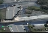
452
452
Oct 29, 2012
10/12
by
KPIX
tv
eye 452
favorite 0
quote 0
it is already at irene levels. and the question is going to be what level does the surge take us to later on this afternoon, later this evening when it's actually high tide. and that's -- if there's a possible area of concern that is it. that's what we are monitoring closely now. as an added precaution today, we are announcing that we are going to close the holland tunnel and the brooklyn battery tunnel the brooklyn battle tunnel renamed the u.l. carey tunnel at 2:00 today. >> to expand on what governor cuomo is talking about, when you heard the concern about storm surge. look over my shoulder, you see the water here at the hudson river and the new york harbor. if it comes over those walls which is five feet over the water level right now, you'll have problems where the water gets into the subway system and the electrical system. i say that it's five feet over, storm surge predicted from 6 to 12 feet. that could be catastrophic. >> wow. >> jim axelrod, thank you. >>> we won't go back to jeff glor in atlantic city.
it is already at irene levels. and the question is going to be what level does the surge take us to later on this afternoon, later this evening when it's actually high tide. and that's -- if there's a possible area of concern that is it. that's what we are monitoring closely now. as an added precaution today, we are announcing that we are going to close the holland tunnel and the brooklyn battery tunnel the brooklyn battle tunnel renamed the u.l. carey tunnel at 2:00 today. >> to expand...
274
274
Oct 30, 2012
10/12
by
CNBC
tv
eye 274
favorite 0
quote 0
you have irene 14 months ago, now this. do your models tell you that this is going to be a more likely scenario over the next, i don't know, 20 or 30 years? >> well, carl, we do model scenarios like this, believe it or not. maybe not exactly this scenario but ones of this kind of severity. and for us i would say it's a manageable event financially. i don't think there's any question that things are different now. at least they have been over the last couple of years. you might expect a company like ours has skilled analytical professionals who do this work in conjunction with industry groups and the weather patterns have been quite different. the question really is, is this a permanent change, or is this just a cycle we're going through which we've had many weather cycles throughout history, as you know. i don't think the answer to that is clear yet. >> right. and, liam, i have to ask you, the impacts on the industry as well as the consumer here, when you hear about these sorts of hurricanes and you hear about the estimated
you have irene 14 months ago, now this. do your models tell you that this is going to be a more likely scenario over the next, i don't know, 20 or 30 years? >> well, carl, we do model scenarios like this, believe it or not. maybe not exactly this scenario but ones of this kind of severity. and for us i would say it's a manageable event financially. i don't think there's any question that things are different now. at least they have been over the last couple of years. you might expect a...
535
535
Oct 28, 2012
10/12
by
KNTV
tv
eye 535
favorite 0
quote 1
in irene at battery park which is where i am tonight, we had three to six feet. we're expecting four to eight feet with this storm here and down the jersey shore as well. that will be higher than what they dealt with during irene. so plan on similar scenarios there. then look at the rainfall. huge areas of two inches plus, four inches plus. locally ten inches in spots in parts of new jersey and the chesapeake bay. if you remember the state of new jersey was one of those heavily fladed flooded back here with irene. then snowfall. to add insult to injury, west virginia, ohio, maryland, pennsylvania and parts of virginia could get 50 inches of snow with this. add all these ingredients together, that means power outages, some which will last for weeks. pennsylvania, new york, west virginia, an 800-mile-wide damage path with this. on the 108th anniversary of the opening of the subway system in new york, we're hoping that in 48 hours parts of it won't be under water. >> places are holding their breath tonight. jim cantore in lower manhattan for us tonight. thanks. >>>
in irene at battery park which is where i am tonight, we had three to six feet. we're expecting four to eight feet with this storm here and down the jersey shore as well. that will be higher than what they dealt with during irene. so plan on similar scenarios there. then look at the rainfall. huge areas of two inches plus, four inches plus. locally ten inches in spots in parts of new jersey and the chesapeake bay. if you remember the state of new jersey was one of those heavily fladed flooded...
198
198
Oct 31, 2012
10/12
by
WBFF
tv
eye 198
favorite 0
quote 0
hey sandy, irene left hurriiane storm, comparing irenee.."hey sandd, irene left her panties here,,come try them on." but rporters werrn't so full of bravadd...when the wiid left a crane dangling over manhattaa... (nats) i don't mean toossund chicken but as soon s we saw and wee &psaw it danglinggwe started runnnng from 57th. hhrricanes and higg risss don't mmx. (nats) uh oh we just had lass breaking out heee, we just had glass breaking. for some it (nats))oo even dress up like a shirtlesssman jogging wearing a horreemask the hurricann horse later tweeted out a picture of himself. butt reporters don'tt lways appreciatt prannsters behiid their baaks... nats) big guy there ou can go talk to people ater who llse theii homes. ffom a fake horse to a real deer. wwbc reports this one was rescuee afttr imagine getting that deer in the headlights look from a deer in tte surf. jeannn moos, cnn new york. coming up... will the weather be gooo enough for trick-or-treating? yourrhalloween forecast... next.youure watching fox 45 good ddy baltimorr. adding up
hey sandy, irene left hurriiane storm, comparing irenee.."hey sandd, irene left her panties here,,come try them on." but rporters werrn't so full of bravadd...when the wiid left a crane dangling over manhattaa... (nats) i don't mean toossund chicken but as soon s we saw and wee &psaw it danglinggwe started runnnng from 57th. hhrricanes and higg risss don't mmx. (nats) uh oh we just had lass breaking out heee, we just had glass breaking. for some it (nats))oo even dress up like a...
301
301
Oct 29, 2012
10/12
by
KPIX
tv
eye 301
favorite 0
quote 0
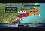
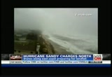
storm could be much worse than irene. here in maryland and farther up the coast including in new jersey. and that's where elaine quijano is, elaine? >> reporter: well, chip, we're in the town of bayhead, new jersey, which is especially vulnerable it sits just ten feet above sea level and like other coastal communities residents here have been ordered to evacuate. >> no, man, we have to go home, state of emergency. >> reporter: the race is on along the jersey shore to leave ahead of hurricane sandy. >> i got it, i got it. >> reporter: ted smith evacuated his 81-year-old mother althea from their house in bayhead. he's worried about the water pushing through their beach front home. >> the ocean will definitely come up this far. i mean if we look at the ocean right now, i mean it's coming up pretty high. >> reporter: throughout the region people from coastal towns are jamming highways and roads to escape the storm. forecasters predict as winds push water on shore, a storm surge could cause water levels to rise six to 11 feet,
storm could be much worse than irene. here in maryland and farther up the coast including in new jersey. and that's where elaine quijano is, elaine? >> reporter: well, chip, we're in the town of bayhead, new jersey, which is especially vulnerable it sits just ten feet above sea level and like other coastal communities residents here have been ordered to evacuate. >> no, man, we have to go home, state of emergency. >> reporter: the race is on along the jersey shore to leave...
163
163
Oct 28, 2012
10/12
by
CNN
tv
eye 163
favorite 0
quote 0
this is a more important storm than irene was and irene was a $15 billion event. >> wow. that was significant. that was connecticut hit very hard. >> connecticut, vermont, new hampshire and into new jersey. >> power was out more than a week in some locations. we'll see you again momentarily. let's check in on a state that is feeling the fury of hurricane sandy right now, and that's north carolina, the outer banks getting the worst of it. maybe the worst of it is actually hitting our george howell. george, you're in kill devil hills. what's new? >> reporter: you know, let's talk about what's happening here on the outer banks. let's talk about the state of north carolina. when you look at the radar, this is the state. you have 40-plus counties that have all declared states of emergency. when you look at the bands here, the bands on the northwest side of the storm, they are affecting this area, and what you're getting is the strong wind. here we're getting the sideways rain mixed with sand here along the ocean, and i also want to talk about storm surge. chad was talking abou
this is a more important storm than irene was and irene was a $15 billion event. >> wow. that was significant. that was connecticut hit very hard. >> connecticut, vermont, new hampshire and into new jersey. >> power was out more than a week in some locations. we'll see you again momentarily. let's check in on a state that is feeling the fury of hurricane sandy right now, and that's north carolina, the outer banks getting the worst of it. maybe the worst of it is actually...
144
144
Oct 29, 2012
10/12
by
FBC
tv
eye 144
favorite 0
quote 0
they are remembering what happened with irene last year. other people are saying, you know, we have been through the storms before. we are hunkering down and we are not leaking. of course, our fingers are crossed for them. connell: along the shoreline, for better or worse with a large group of people. dagen: breaking news on the water moving into new york city and manhattan our sister station is reporting that parts of fdr drive, this is one of the two main arteries in and out of new york city that runs along the edge of manhattan. on the east side of manhattan is fdr drive, that is now underwater according to fox five. fdr drive is on the east side of manhattan. this is a critical artery of moving traffic in and out of new york city. at 2:00 p.m. eastern time, both the holland and brooklyn battery tunnel will be closing. if people are not in the city or out of the city in a matter of hours, you will not have a choice. you will have to stay right where you are. dagen: if you went up the right side of the horseshoe there, the east river is t
they are remembering what happened with irene last year. other people are saying, you know, we have been through the storms before. we are hunkering down and we are not leaking. of course, our fingers are crossed for them. connell: along the shoreline, for better or worse with a large group of people. dagen: breaking news on the water moving into new york city and manhattan our sister station is reporting that parts of fdr drive, this is one of the two main arteries in and out of new york city...
499
499
Oct 28, 2012
10/12
by
KGO
tv
eye 499
favorite 0
quote 0
irene being the last time. we didn't hit that hard enough, right at the coast, from jersey shore up through new york city, long island, you get the bigger numbers. because of the shape of the land, it's going to help that southwest to -- southeast to the northwest flow. other spots will have a surge. we're talking 60 to 80 miles an hour winds in that red area, boston, pittsburgh is included. washington, d.c., even. the purple area all of the way through maine, 40 to 60-mile-per-hour winds. you have emphasized sam how many times how big this is. this storm is going to here for a long time and we'll be following it throughout the entire thing. >>> thank you, ginger. >>> meanwhile, 5,000 miles to the west, another breaking story we're watching very closely right now. a massive earthquake off the west coast, triggering a tsunami for hawaii. our affiliate in hawaii reports. >> reporter: very serious situation in hawaii. earlier this morning, the civil servicish shug an evacuation. they are seeing some of those tsuna
irene being the last time. we didn't hit that hard enough, right at the coast, from jersey shore up through new york city, long island, you get the bigger numbers. because of the shape of the land, it's going to help that southwest to -- southeast to the northwest flow. other spots will have a surge. we're talking 60 to 80 miles an hour winds in that red area, boston, pittsburgh is included. washington, d.c., even. the purple area all of the way through maine, 40 to 60-mile-per-hour winds. you...
329
329
Oct 29, 2012
10/12
by
WJLA
tv
eye 329
favorite 0
quote 0
last year, irene, and driving through the wall street area. now, last year, you and i were standing almost exactly here to get a very different situation. the surge isn't going to bring just water. it's going to bring force. and that's why we don't know how it will affect an area like this already in evacuation. people aren't living in the area where we are right now. if the forecasters, not you, sam, but everybody in general, close to accurate, this place is going to look very different tomorrow. maybe permanently. >> chris, we're standing right here where the water is up on the edge. last year where we were here, the water was two or fee below that. didn't really get to the top until the middle of the storm. >> absolutely. >> amy. >> chris, sam, thanks so much. we want to take a look at times square. because normally at this hour, it's crammed with traffic. well, look at that, it is a virtual ghost town. sandy has forced officials to shut down the subways for the second time in its history. josh is out on times square with the very latest. j
last year, irene, and driving through the wall street area. now, last year, you and i were standing almost exactly here to get a very different situation. the surge isn't going to bring just water. it's going to bring force. and that's why we don't know how it will affect an area like this already in evacuation. people aren't living in the area where we are right now. if the forecasters, not you, sam, but everybody in general, close to accurate, this place is going to look very different...
506
506
Oct 29, 2012
10/12
by
KGO
tv
eye 506
favorite 0
quote 0
just a year ago waiting for hurricane irene's arrival. millions of people have taken the city officials' advice and stayed home today. >> sandy causing a real mess for flyers, too. the impact felt all the way to the west coast. some planes still in the air sunday night. but look at this morning. the skies much emptier. jim lavila has the details. >> reporter: nearly a total ground stop here. the flights are canceled. almost all across the country, whether it's trains, butss, and also planes, have been canceled this morning. take a look what we have here at reagan national. this airfield, this corridor, completely empty. look at the boards over here, they become cancellation walls at the airports tell people to stay home. >> reporter: this morning, much of the nation as a standstill. the ferocious superstorm crippling much of america's transportation system. amtrak trains and airports from north carolina to boston virtually shut down. nearly 7,000 flights canceled. most either fly from or through one of the hubs in sandy's path. >> you pre
just a year ago waiting for hurricane irene's arrival. millions of people have taken the city officials' advice and stayed home today. >> sandy causing a real mess for flyers, too. the impact felt all the way to the west coast. some planes still in the air sunday night. but look at this morning. the skies much emptier. jim lavila has the details. >> reporter: nearly a total ground stop here. the flights are canceled. almost all across the country, whether it's trains, butss, and...
418
418
Oct 29, 2012
10/12
by
FOXNEWSW
tv
eye 418
favorite 0
quote 0
irene brought in $4.3 billion in damage last year. it was one of the top ten costliest u.s. returns in history. the insurance adjusters are already on the scene they could go in as early as wednesday and write checks on the spot for policyholders>> wall street some of the banks are heclosed today. >> they are closed today and likely tomorrow. electronic trading late last night much of lower manhattan has already been evacuated. they are operating on a work at home basis. heather? >> here is something of major concern we have seen gas prices dip recently but they could be on their way up. that's because refineries could be shut down. >> 6 northeast oil refineries could be affected they have 6.2 million of barrels a day. october 1st the official month in the 2013 model year. if some of the car dearlies shut down they may not be unloading the vehicles. >> keep our fishings crossed on gas prices and insurance issues as well. >> lauren thank you so much. >> good to see you. quick look at headlines. he was the prime suspect. ainsley take it away from here. >> he was the prime susp
irene brought in $4.3 billion in damage last year. it was one of the top ten costliest u.s. returns in history. the insurance adjusters are already on the scene they could go in as early as wednesday and write checks on the spot for policyholders>> wall street some of the banks are heclosed today. >> they are closed today and likely tomorrow. electronic trading late last night much of lower manhattan has already been evacuated. they are operating on a work at home basis. heather?...
200
200
Oct 29, 2012
10/12
by
WUSA
tv
eye 200
favorite 0
quote 0
already yesterday afternoon it was looking so much worse then that it was at the peak of hurricane irene. so that's why we are under a mandatory evacuation order. i have not seen just driving around hardly anybody out on these roads. that's exactly what we want to be seeing. just look at this water. it is still coming in. this wind when it comes in, it's blowing your car around. you just can't be driving through stuff like this. so high winds, lots of rain. i couldn't quite hear what you said but high winds, lots of rain. it's only going to be getting worse. if you're able to watch this from home, just stay there. you're in the best place to do it. we have businesses boarded up, folks staying in. most of the electricity is still on. we haven't seen a lot of power outages here in this part of rehoboth beach just yet. of course that could certainly change as hurricane sandy barrels even closer towards us. back to you guys. >> good advice right now as you still have power to power up all of those cell phones, smartphones, everything. good advice. live in rehoboth beach, delaware. >>> koim i
already yesterday afternoon it was looking so much worse then that it was at the peak of hurricane irene. so that's why we are under a mandatory evacuation order. i have not seen just driving around hardly anybody out on these roads. that's exactly what we want to be seeing. just look at this water. it is still coming in. this wind when it comes in, it's blowing your car around. you just can't be driving through stuff like this. so high winds, lots of rain. i couldn't quite hear what you said...
153
153
Oct 30, 2012
10/12
by
FOXNEWS
tv
eye 153
favorite 0
quote 0
jenna: compared to irene, ron, how does this compare? >> this definitely has surpassed irene in terms of the amount of damage that we've seen. as i said, we just started our as -- assessment process. we'll be out there seeing how much worse than irene this is. jenna: sounds like you're firing on all cylinders, ron, pardon the expression if there is no power. great to have you talk with us today. we wish you best of luck as you work around the clock to get this fixed. >> thank you. jon: cleanup efforts are underway across the mid-atlantic region even as the storm continues on. countless streets an homes are underwater. we have the very latest from hard-hit ocean city, maryland. we'll be speaking with the mayor in just a bit. >>> the powerful superstorm slamming after lach chan states with snow fall. dramatic images of early season snowfall coming up [ man ] ring ring... progresso this reduced sodium soup says it mahelp lower cholesterol, how does it work? you just he to eat it as part of your heart healthy diet. step 1. eat the soup. all
jenna: compared to irene, ron, how does this compare? >> this definitely has surpassed irene in terms of the amount of damage that we've seen. as i said, we just started our as -- assessment process. we'll be out there seeing how much worse than irene this is. jenna: sounds like you're firing on all cylinders, ron, pardon the expression if there is no power. great to have you talk with us today. we wish you best of luck as you work around the clock to get this fixed. >> thank you....
198
198
Oct 29, 2012
10/12
by
CNBC
tv
eye 198
favorite 0
quote 0
because of irene, are you even more prepared at this point, governor? >> well, we certainly have learned a lot with every storm. we have a great first responder emergency response community in our state. they've been preparing for many days. that being said, this is a significant one. we're seeing a lot of flooding already. we expect people will be without power for a long time. it's a slow moving storm. going to be several tidal cycles. significant impact throughout the state. >> compared to last year with both of those events that we had, you think there's going to be longer and more people without power? >> i do. i think the storm will be here longer for sure. it's slow moving. we expect more people without power. the utilities have been bringing people in from throughout the country so that's a positive. the challenge is that it's so long lasting, the winds are going to be so strong that it could be some period of time before the utilities can actually put people up in their bucket trucks to put poles back up. >> are the centers full near the coast?
because of irene, are you even more prepared at this point, governor? >> well, we certainly have learned a lot with every storm. we have a great first responder emergency response community in our state. they've been preparing for many days. that being said, this is a significant one. we're seeing a lot of flooding already. we expect people will be without power for a long time. it's a slow moving storm. going to be several tidal cycles. significant impact throughout the state. >>...
279
279
Oct 30, 2012
10/12
by
WMAR
tv
eye 279
favorite 0
quote 0
this storm crushed irene. absolutely no comparison. pieces of buildings falling in the street like that one there. >> you saw the tree. at my family's home, we're okay, just -- and the debris that is flying. that we have to look out for. >> the lower e this broadcast is real time captioned by ca
this storm crushed irene. absolutely no comparison. pieces of buildings falling in the street like that one there. >> you saw the tree. at my family's home, we're okay, just -- and the debris that is flying. that we have to look out for. >> the lower e this broadcast is real time captioned by ca
802
802
Oct 29, 2012
10/12
by
WRC
tv
eye 802
favorite 0
quote 0
they expect this to be even worse, the storm surge to be even worse here than it was during irene. so that's the major concern. there's the mandatory evacuations up and down the connecticut coast. the good news is that most people are heeding those evacuation orders. the other big concern is power outages. all the wind they are expecting to get up here, because the wind is going to be very strong up on the northern edge of this storm. the wind will cause a lot of power outages along with that flooding. they expect -- connecticut light and power expect as many as 600,000 people to be without power here in connecticut for days on end. during irene they were without power for days on end as well so everybody in connecticut is expecting the worst and heeding the orders and just trying to prepare for t.matt? >> all right. katy tur in mystic, connecticut. thanks. connecticut's governor is here with us this morning. >> good to be here, matt. >> you said this could be the biggest threat to face people in years. >> the tides will affect western long island so that portion from new haven dow
they expect this to be even worse, the storm surge to be even worse here than it was during irene. so that's the major concern. there's the mandatory evacuations up and down the connecticut coast. the good news is that most people are heeding those evacuation orders. the other big concern is power outages. all the wind they are expecting to get up here, because the wind is going to be very strong up on the northern edge of this storm. the wind will cause a lot of power outages along with that...
183
183
Oct 29, 2012
10/12
by
FOXNEWS
tv
eye 183
favorite 0
quote 0
joe, i was with you during hurricane irene and this seems like it's much worse. >> it does seem worse already. it was high today and higher now. >> why aren't people leaving? >> well, it takes a long time to get the long time residents off the island and last year there wasn't as much damage as expected and-- >> this is bigger, stronger and much more dangerous and already seeing the water hit against the docks and much more damage. >> it does and tides are pretty high and again, it's two times day and the water will run out and people are fairly comfortable staying the ones that have stayed they've been here a long time. >> well, best of luck to you. geraldo, joe is having a storm party in anticipation of sandy arriving and hopefully spirits will stay up. back to you geraldo. >> geraldo: safe me a rum drink, brother. okay? it sounds okay. and listen folks, this is for real. now, the real danger, i have a dock on the hudson river. i have-- i'm telling you that, i fully anticipate my dock to be over, over run by the river, as it was last year. but this last year was, i think, a three fo
joe, i was with you during hurricane irene and this seems like it's much worse. >> it does seem worse already. it was high today and higher now. >> why aren't people leaving? >> well, it takes a long time to get the long time residents off the island and last year there wasn't as much damage as expected and-- >> this is bigger, stronger and much more dangerous and already seeing the water hit against the docks and much more damage. >> it does and tides are pretty...
249
249
Oct 29, 2012
10/12
by
KRCB
tv
eye 249
favorite 0
quote 1
. >> reporter: last year's hurricane irene was the most recent storm to pummel the northeast. it cost the industry roughly $4.3 billion in insured losses. analysts can't yet predict how steep losses from sandy will be, but they say the companies with the most exposure include: liberty mutual, travelers, allstate, and chubb. auden thinks those firms will be able to shoulder a financial hit if the storm's damage mirrors that of irene. >> with every event companies gather more information on potential losses, so catastrophe losses become much more sophisticated. companies use those to measure aggregation of losses and potential losses from a given event. >> reporter: damage from wind, falling trees, and rain coming through roofs is covered by standard insurance policies. but analysts fear much of the damage from sandy to homes and businesses is likely to come from storm surge flooding which isn't. the insurance information institute estimates roughly 300,000 homes in the northeast could be vulnerable to this type of event. but the institute is optimistic many homeowners have floo
. >> reporter: last year's hurricane irene was the most recent storm to pummel the northeast. it cost the industry roughly $4.3 billion in insured losses. analysts can't yet predict how steep losses from sandy will be, but they say the companies with the most exposure include: liberty mutual, travelers, allstate, and chubb. auden thinks those firms will be able to shoulder a financial hit if the storm's damage mirrors that of irene. >> with every event companies gather more...
202
202
Oct 27, 2012
10/12
by
WRC
tv
eye 202
favorite 0
quote 0
a lot of people haunted by last year's hurricane irene, see what they are doing to prepare. >> also, pictures >> hurricane sandy expected to come ashore on monday and people across the north east are making plans to try to get out of harm's way. hurricane sandy is blamed for at least 40 deaths in the caribbean. >> it is now turning towards the u.s. bringing heavy rains, high wind and flooding to much of eastern seaboard. daniel lee has the latest now from chesapeake beach, maryland. >> hurricane sandy poundedity way through the caribbean today, ripping homes apart and leaving streets under water. at least 40 people died in haiti, cube why and jamaica. as sandy moves up the coast, setting to clobber the northeast, people are preparing for the worst. >> we just have to do it, m mill ford beach connecticut, boarding up his brand new home. last year's hurricane irene forcing him to rebuild, now he is hoping sandy won't do the same. >> you know, you have to prepare. >> from virginia to new england, several governors declaring emergencies and issuing warnings. >> assume there is an elongat
a lot of people haunted by last year's hurricane irene, see what they are doing to prepare. >> also, pictures >> hurricane sandy expected to come ashore on monday and people across the north east are making plans to try to get out of harm's way. hurricane sandy is blamed for at least 40 deaths in the caribbean. >> it is now turning towards the u.s. bringing heavy rains, high wind and flooding to much of eastern seaboard. daniel lee has the latest now from chesapeake beach,...
43
43
Oct 28, 2012
10/12
by
MSNBCW
tv
eye 43
favorite 0
quote 0
much different than irene. we have seen people in the last few hours really taking this storm a little more seriously. also new yorkers taking it in stride. >> we have two children. 2 and under. so, it's a bit of a hassle. after going through what we did last year, we are glad the city is taking precaution. >> we are going up state a little bit. stay there a couple days. when they let us back down, we'll cobb back here. if i was young and sting l, we'd still be here. >> reporter: it's not just the mandatory evacuations taking place in the city. you have the subway system that will shut down. first of all, subways at 7:00 tonight. buses at 9:00. you have ferry service in the area that is shutting down as well. the port authority is taking steps to ramp down that construction at the world trade center sight, securing everything they can. broadway shows tonight going dark through tomorrow and perhaps tuesday. >> michelle franzen reporting from lower manhattan. thanks so much. hurricane sandy as we have been talkin
much different than irene. we have seen people in the last few hours really taking this storm a little more seriously. also new yorkers taking it in stride. >> we have two children. 2 and under. so, it's a bit of a hassle. after going through what we did last year, we are glad the city is taking precaution. >> we are going up state a little bit. stay there a couple days. when they let us back down, we'll cobb back here. if i was young and sting l, we'd still be here. >>...
88
88
Oct 29, 2012
10/12
by
CNBC
tv
eye 88
favorite 0
quote 0
this is similar to what we saw with irene last year. there will probably be an upward shift in the national average in the days ahead. irene last year took a similar path, knocked out similar refineries. the national average ended up increasing about 8 cents per gallon. so while the drop in demand on east coast is pretty significant, we could be looking at some longer term problems with these refineries being offline. >> john, do you agree? >> yes, i do. i think it is all going to come down to power, power, power, whether or not the frefineries can get back online, but also whether the terminals are closed that receive imports, not to mention the colonial pipeline even though they have installed generation capacity up and down the line. that will need to get restored for this more rosy scenario we are counting on. >> john, aren't we just building up stockpiles today, tomorrow, maybe wednesday and thursday? >> i do, brian. but to the extent people get back on the road and back to work, we can rip through them. we'll need to see a for-sur
this is similar to what we saw with irene last year. there will probably be an upward shift in the national average in the days ahead. irene last year took a similar path, knocked out similar refineries. the national average ended up increasing about 8 cents per gallon. so while the drop in demand on east coast is pretty significant, we could be looking at some longer term problems with these refineries being offline. >> john, do you agree? >> yes, i do. i think it is all going to...
 Live Music Archive
 Librivox Free Audio
 Metropolitan Museum
 Cleveland Museum of Art
 Internet Arcade
 Console Living Room
 Books to Borrow
 Open Library
 TV News
 Understanding 9/11